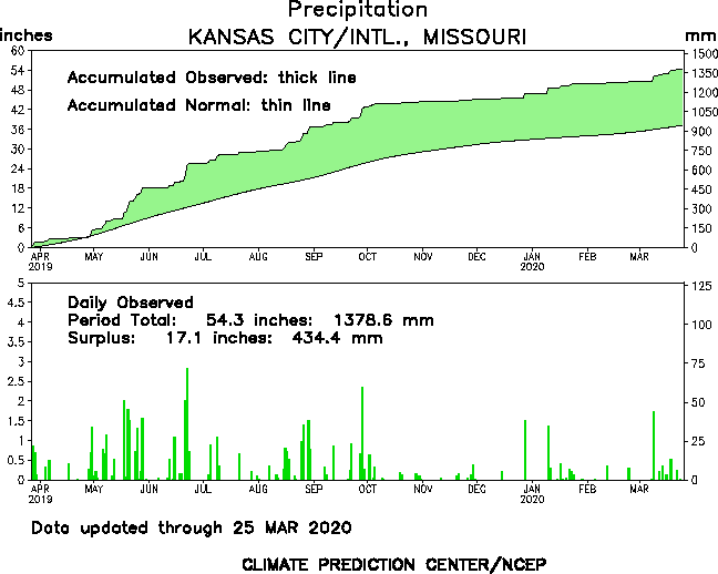
The dryness though is now becoming something a bit more than a curiosity. We've really not had a decent (.50"+) rainfall for over two months. IF this would be the precip set-up heading into summer, our chances of having a devastating drought during the summer would be on the increase. From a yearly standpoint we are running some 5.5" below average, most of that has occurred since 9/1 as we're some 5.9" below average in the 50+ days. While at times this year we've been in the positive category for monthly rainfall, it has been a struggle to stay wet for any length of time. Take a look at this next map showing a running total of precip since last October (which went dry in the fall of 2010). It shows us, essentially being in a deficit for the last year+ when taking into account last fall's weather.
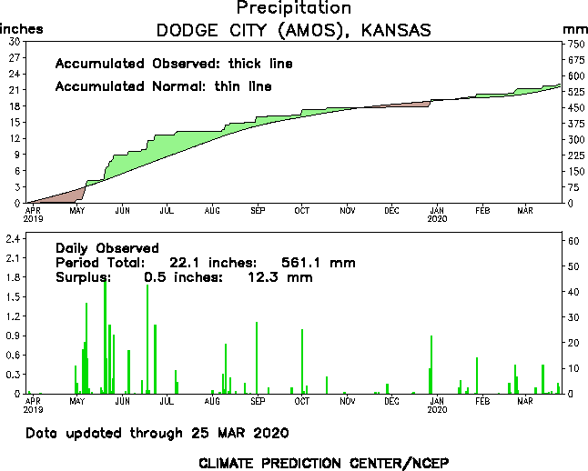
While pretty dry, this in no way compares to the devastating drought going on through the western plains states...take a look at the same chart for the Dodge City area...
Again, give us avg rainfall for the last 2 fall seasons and we'd be golden (and a lot greener) but that has not been the case. Check out the last 30 days or so and notice on the following map where the deficit of rainfall is centered...

Our next frontal boundary is going to do about what I expected it to do, push so far to the south that the moisture that will be overrunning it will be to far south of the area. I wouldn't be surprised about the area from KC south getting some scattered light rains/showers/sprinkles but anything would probably just be a tease and amounts should be under .10" for almost all of us. The wave/trof in the upper levels of the atmosphere will blow through here, so we should see clearing skies on Thursday with highs near 50 and then another frost/freeze later this week. This should be followed by a moderating weekend next weekend.
Well that's about all I can think of for a Sunday afternoon. Enjoy the great weather through Tuesday.
Joe
No comments:
Post a Comment