Sunday, August 28, 2011

Thought I'd start with this quote today...this is from Howard Kurtz who is a media critic on CNN...he did a post today called Hurricane Hype. I didn't really watch any of the cable coverage of this...so I don't know whether to agree or not...perhaps you want to add your thoughts as well...here is a money quote though...

Someone has to say it: Cable news was utterly swept away by the notion that Irene would turn out to be Armageddon. National news organizations morphed into local eyewitness-news operations, going wall-to-wall for days with dire warnings about what would turn out to be a Category 1 hurricane, the lowest possible ranking. "Cable news is scaring the crap out of me, and I WORK in cable news," Bloomberg correspondent Lizzie O'Leary tweeted.
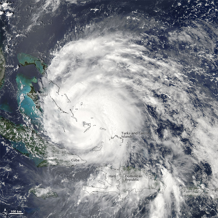
Millions were/are without power, at least 14+ have lost their lives, and flooding is raging through the NE and New England this afternoon. Good afternoon and welcome to the FOX 4 Weather Blog. We'll start with Irene as this will be the last time I write about here. it's been fascinating to watch her for the last couple of days. The former hurricane, now a Tropical Storm will fall apart over the next 1-2 days across eastern Canada. It put on quite the show apparently in the NYC area this AM as it was moving N at close to 25 MPH. NYC hasn't been hit by an eye passage in more than 100 years. I'm not sure if today Irene will qualify. Even though the center passed over the city, the NHC downgraded the storm from hurricane to tropical storm criteria as it did so. I'll try and do more research in the course of my afternoon. Here is a look at the hurricane from space when it was minutes from making landfall again in NY...it did so previously in NC and NJ...the final landfall was NYC...


The storm however wasn't, from an outside looking in view as bad as the potential. It appears the NYC area had 40-60+ MPH winds at their peak. I did see some 70+ wind gusts. The flooding/surge were the expected bigger issues and there are reports of water rescues from the AM...there are also lots of trees down and that has caused significant power issues. It does seem like the flooding scenario is all it was cracked up to be. NYC has had their wettest month in record history with 19.02" of rainfall(!). Our record for the most rainfall in any month is 15.47"  set back in July of 1992. Pretty impressive.

The storm did produce a wind gust to 91 MPH in Sayville, NY, which is out on Long Island. Rainffall totals were in the neighborhood of 4-10" which was about the amounts expected. Here are some of the higher wind speeds that I could find for you from the NE part of the country...

NY: Sayville...91 MPH
CT: Bridgeport...63 MPH
NJ: Robins Reef Lighthouse...70 MPH

Farther south the folks from Weatherbug have put this together for you...


Meanwhile over the course of the past couple of days...the rainfall has been in excess of 20" in spots...here is a recap up the eastern seasboard...


Philadelphia has also set a record for the most amount of rainfall in any month with 18.16" of rainfall...not including if they got any today or not.


So was it a hyped up storm...was it not? Was the coverage overdone? Was it what they expected? The only thing I can add to this is that I feel that this thing may not have been a hurricane for quite some time. Technically you need to have 74+ MPH winds (sustained not in gusts) and really from yesterday onwards it was tough to find anything like that. Again this doesn't pertain to wind gusts...A tropical storm can have wind gusts to 75 MPH...or even 85 MPH...I wonder if by downgrading it to a tropical storm, there might have been concern that folks would ease off their preparation. Perhaps not...but aside from a very low central pressure, it was really tough to verify this as a hurricane after it go to the VA/NC border. Again the wind gusts were there, and were there even this AM...but the "sustained" winds were rather tough to verify.

Onto our weather...we're int he low-mid 80s as I type this...there is a disturbance that will create rain and storms across parts of our viewing area this afternoon. Showers/storms are moving from the NW to the SE associated with an MCV near Atlantic, IA. Here is a radar snapshot from Omaha...


The MO side has the better chance of seeing some rainfall...perhaps skirting the NE side of the metro depending on how the activity NW of St Joe holds up. It was developing as I typed this blog up. We'll have better chances later MON into TUE early AM...then it gets hot around these parts again with highs soaring into the 92-96 range I think.

Have a great week and I'll see you again after Labor Day.

Joe
,,,,

Saturday, August 27, 2011

Irene is ashore and maintaining it's strength at least from an advisory standpoint. Actually the pressure dropped a bit this AM for a few hours even after landfall. It should be noted that it came ashore in a swampy/marshy area with lots of water so it's not surprising that it's barely holding it's own right now. From a satellite perspective through it does look like she's decaying...slowly though. So far the death toll is up to 4 and 650,000 are without power in VA and NC...so far....

Landfall was @ Cape Lookout, NC...and she came ashore packing winds of 80-90 MPH with gusts to over 100. The highest wind gust was from Cedar Point Ferry Terminal, reporting a gust to 115 MPH. Atlantic Bch had a gust to 101 and New Bern topped of @ 84 MPH...

Rainfall is impressive 6-12" or so being reported...her is a doppler indicated image of the amount of rain that's fallen...

Click on all the images to make them larger...

From a satellite standpoint here is the storm a few hours after landfall...looks pretty impressive for sure...


Right now the storm is not far from Cape Hatteras, NC...and will be re-emerging back into the W Atlantic later today...


The latest from the NHC is...

ABOUT 45 MI...70 KM WNW OF CAPE HATTERAS NORTH CAROLINA
ABOUT 95 MI...155 KM S OF NORFOLK VIRGINIA
MAXIMUM SUSTAINED WINDS...85 MPH...140 KM/H
PRESENT MOVEMENT...NNE OR 15 DEGREES AT 13 MPH...20 KM/H
MINIMUM CENTRAL PRESSURE...950 MB...28.05 INCHES


It should pass near or just to the east of NYC sometime tomorrow AM...winds should be in the 50-70 MPH range there...everything in NYC is now shut down...subways/trains/buses/arriving flights...the "city that never sleeps" is taking one big weekend nap it seems like. Rainfall amounts there are forecasted to be 5-10+"...with lesser amounts across the eastern part of the region, where the winds will be stronger...

The positive is that the storm will be moving along and won't stall creating insane amounts of rain. The bad news is that NYC just broke their August record for rainfall...old record was 12.36". I wonder if this may turn into their wettest month ever? Also points out with such saturated soils up there, why there may be lots of trees down hence power outages tomorrow.

More on Irene as I get information...and of course tonight @ 6/9/10...

Our weather today is tame. Readings as of this writing are close to 88 and we should finish the afternoon near 90 or above in some areas on the south side of town. A weak trof has just passed through, switching our winds to the N...also, in a nod to the wetness farther north of here, allowing the dewpoints to actually rise behind the wind shift line. Ahead of it...dews are in the 50s-65...behind it dews rise to the 70s, so it may get muggier as the afternoon goes along. As of this writing KCI dewpoint was 59, St Joe's was 71 and Fall City's was 75...all now with light north winds.

I'll still keep the rain chance in the forecast for tomorrow PM, as a small disturbance should ripple through the area...the NAM doesn't really give us anything, the GFS which never really did...now does...something is going on in there...timing would be from lunchtime onwards from NW to SE...

A perhaps better chance will come Monday night into Tuesday as a stronger disturbance along the leading edge of some hotter air moves into the region. There should be one pretty hot day on THU before a cold front moves through the area...

Joe


Thursday, August 25, 2011

Irene is fluctuating a bit in intensity this AM...however the conditions in the atmosphere remain very favorable today for strengthening...so winds may increase somewhat as the day goes along...here is a photo from yesterday showing the storm moving through the Bahamas...there were wind gusts reported to be near 100 MPH with the storm itself...


Here are the first visible pictures this AM...


As far as the forecasted track goes...no real changes...still looking like a scraping of the outer NC Banks then a more NNE movement up the coastline towards NY...


The winds should be on the decrease as it moves off the mid-atlantic coastline and encounters some cooler waters. The latest recon report from 8:30 AM shows that the storm may actually have even lesser core winds surrounding the eye...and that the eye is about 15 miles across...here is an update from the folks @ the NWS in Washington...


...MAJOR HURRICANE IRENE TO STRONGLY AFFECT THE EAST COAST FROM NC INTO THE NEW ENGLAND THIS WEEKEND...

THE LATEST NUMERICAL GUIDANCE CONTINUES TO ADJUST WESTWARD AS HAS
THE LAST SEVERAL NHC TRACK FORECASTS WHICH NOW HAVE EYE OF IRENE
COMING THRU THE NORTH CAROLINA OUTER BANKS LATE SATURDAY BEFORE
GRAZING THE DELMARVA AND NEW JERSEY THEN MOVING INTO THE NORTHEAST ON SUNDAY. THIS POTENTIALLY COULD BE EXTREMELY DESTRUCTIVE WITH MASSIVE DISRUPTIONS TO SOCIETY AND COMMERCE ALONG ITS ENTIRE TRACK WITH VERY HIGH WINDS/STORM SURGE/OCEAN OVERWASH/BEACH EROSION/SOUND AND BAY SIDE COASTAL FLOODING AND EXTREME TIDE POTENTIAL. WIDESPREAD HEAVY RAINS IN THE 6-10 INCH RANGE WILL BE COMMON WITH GREATLY INCREASED INLAND FLOOD POTENTIAL. REFER TO THE NHC FOR THE LATEST FORECAST OF IRENE ALONG WITH LOCAL NWS WARNINGS/STATEMENTS AND ADVISORIES FROM NC INTO NEW ENGLAND.

I'll have more throughout the day with another update sometime before 3PM...


Joe

Wednesday, August 24, 2011

I'll let the guys deal with the local forecast stuff however I will tell you that a cold front has moved into the area, typically we'd be concerned about storms later this afternoon, but aloft we're very warm so we're essentially capped. There may be some storms, isolated in nature, developing towards the south of the metro later this afternoon, but the chances right now seem pretty low for any widespread activity.

Instead this blog will talk about Irene which, as expected, has been slowly strengthening and organizing over the past couple of days. Also as expected the threat has shifted farther eastwards along the eastern seaboard and there is the potential the storm may just graze the outer banks of NC. There is a mandatory evacuation order in effect for a few areas in far eastern NC which are only accessible by boat/. Irene now is packing winds of 115 MPH and is considered a major hurricane. She is moving towards the NW at close to 15 mph and has developed an eye, as is typical of maturing hurricanes. Take a look at the visible satellite photos which show this rather nicely.


The island being hit is Crooked Island...the next island in the path is Long Island...in the Bahamas.


Here is the forecasted path of Irene...I more or less agree with this path however I wouldn't be surprised if the northern most part of the path is shifted even farther eastwards.


The key to how far east the storm will eventually go is a trof across the NW part of Canada

It's interesting that there has been some rather remarkable agreement over the past 12+ hours in the model data with the forecast...there are dozens of models that are looked at to try to figure things ouot...here is a look at all of them...


Notice that now there are more than a few suggesting that this storm may end up more of a fish storm, with a path out to sea...this is certainly possible and a trend that needs to be watched. That trof, and how far south it digs or doesn't will decide how close to the NE coastline the storm gets...if it digs far enough to the south it would allow the storm to come farther up the coastline before moving more NNE...here is the position that is forecasted from the NAM. The trof by then moves through the Great Lakes.


Should Irene get closer to the NE...it will be one of the more significant weather events of the year, in a year of it seems nothing but significant weather events. Remember the worst part of a hurricane in on the eastern side. Typically the western side of the hurricane, while rough, is not as bad. Also remember that typically as these things move farther up the coast, while the core will usually weaken because of cooler ocean temperatures the storms often broaden out. While the core winds decrease, the strong winds actually expand outwards.

So while the metropolises of the NE need to be very concerned about this storm...the ones that really need to be concerned are from NY up through Boston. The direction of the winds as the storm moves near the coastline may allow water to pile up from Long Island Sound into the western part of the Sound...this will create flooding issues that potentially could be very severe, in addition to the winds and heavy, flooding rainfall.

So there is a lot to ponder with this storm, and the NE part of the country is certainly not out of the woods yet. The timing of all this would be over the weekend.

Joe


asdf

Sunday, August 21, 2011

A quiet weather day her in the KC region, with no threat of storms for the rest of the afternoon through this evening so get out and enjoy one of the last summer time weekend afternoons we have left. We're just a couple of weeks away from the unofficial end of summertime in these parts as Labor Day is approaching so with highs this afternoon in the seasonable 80s, get outside. Granted it's seasonably humid but really in the big scheme of things not too bad.

We'll talk about our additional rain chances in a bit, but the subject and item of discussion for the week will be the future of what is now Irene in the NE Caribbean now. Irene continues to look better on the satellite images compared to yesterday, although at this point it's not strengthening that much. It quickly was upgraded directly from a disturbance, past depression status, to tropical storm status yesterday evening, and 24 hours later it's packing winds of 50-60 MPH. Our computer forecasts for days have speculated that IF anything were to form from the original disturbance out int he central Atlantic, that it wold be a player int he FL/SE part of the country's weather by the end of the week...and that hasn't changed...good job on the models for picking that potential out from so far away.

The devil obviously is in the details, because the track of Irene, which is still organizing, and seeing it's center relocate farther northwards with time, is one that favors many hours over the islands and mountains of the land masses down there. Of all the tracks for a storm that needs to be over the warm waters to intensify, the next 72 hours forecast track is probably the least favorable for a storm to take...here is the afternoon NHC forecast...


Sadly it looks like Haiti/Dominican Republic will be getting lots of rainfall and gusty winds out of this, if nothing else. Also Puerto Rico, which is pretty water logged as is, will see an additional 4-12" of tropical rainfall out of this as well as the potential for 50-70 MPH winds depending on how much she wants to strengthen between now and tomorrow AM. The track though of the storm over Hispaniola is through the core of the highest terrain. Tropical systems hate mountains and there are some rather big ones there. Here is a relief map from wikipedia showing what I'm talking about...


With Irene's forecast through that area over the course of MON AM through TUE AM a long one, that will certainly rip/weaken the storm quite a bit tomorrow afternoon...then the storm comes back offshore TUE PM just to end up quickly interacting with the eastern part of Cuba, which while pretty flat, will not allow the storms engine to suck in the vast about of warm water vapor it needs from the ocean to start humming again. it's not until sometime THU when the storm gets out towards the FL Straits or the Bahama Island chain that it will once again start to get it's act back together again. By this time there is no telling what kind of shape it'll be in. I've seen many cases where these Caribbean islands really do a number on the circulation of the storm and it just doesn't have enough time to really organize again before it makes US landfall.

With the center of the storm reforming farther and farther northwards my suspicion is that the risk of landfall may shift farther eastwards, perhaps more away from S FL and more towards the SE coastline. basic geography indicates that IF the storm is moving more towards the NW or NNW, with the shape of the E FL coastline that it's VERY possible that the worst of the storm, should it indeed move farther east than what NHC thinks, may stay across the offshore FL waters, then perhaps be more of a threat for GA/SC. It's actually pretty rare for the GA coastline to be hit by a landfalling storm. Some of the latest modelling is indeed farther east with the storms path compared to the NHC 5 day track from early this afternoon...I think it makes sense at this point. The GFS and Canadian bring the storm finally ashore from near Savannah (GFS) to the outer banks of NC (Canadian). Here is a quick look at there longer range forecasts which WILL NOT be correct...the errors are rather large in these things from 24 hours out, let alone close to 5 days out. By the way, the latest EURO is almost a carbon copy of the path of the Canadian...I'm expecting that the "official" track will be adjusted towards the east with the new advisory later this afternoon based on the available data...


Of course there are the intensity issues that have been briefly talked about, and with a track farther eastwards, this will bring a couple of things into play should the storm be able to tap into the vast reserves of energy that will be available. 1) would be the longer period of time the storm is in the warm waters off the SE coastline...and 2 would be the even warmer conveyor belt waters of the gulf stream which could potentially act as premium gas for the tropical cyclone engine.

Still a lot of time to figure this out...again I'm favoring a farther east track than what the Hurricane Center thinks at this point. NO I wouldn't cancel my FL trip yet but yes IF you're heading towards the Carolina's I would be somewhat concerned...

Our rain chances are somewhat muddled as weak disturbances caught int he flow will try to ignite storms tomorrow and Tuesday. There are some indications that we could get pretty darn hot on WED, especially towards the south of the I-70 corridor...something in the 95-100 range as a weak front pushes towards the area...SW flow has the potential to really heat it up, and again remember that temperatures to the south of here have been easily into the 90s and 100s lately again...need to watch that for a sneaky 100 day in some areas. I do wonder though with ALL the rain we've seen if that will take the edge off the highs by a few degrees. There is a lot of moisture that needs to get baked out of the soil again. I'm forecasting highs near 92...I may bump that up a couple of more degrees this afternoon.


Have a great week!

Joe

Saturday, August 20, 2011

Around these parts, usually if you just wait long enough, things change...we've gotten from brutally hot weather to more seasonable days this month. We've gone from really needing some rainfall to having, in some cases now too much again in spots. Today is a cloudy gray, showery day with readings mainly in the 70s in the region.

Of course the bigger story continues to be the severe weather that pelted many in the area again last night, knocking out power to 10s of thousands, toppling trees and downing power lines. There were several reports of SOFTBALL sized hail (impressive for this time of year here) and winds of 60-80 MPH through the area..

These are the reports from last night, all the green dots represent severe winds, while the blue dots show the larger hailstones....


Looking at the KCP & L website, there are still some 20000 customers without power this afternoon, they're making a dent in that number but it's going to take awhile to get where they want to be. Some 8000 customers on the Westar grid are without power as well.

That was night #2 and really the 3rd time, going back to the 1st weekend of the month that powerful storms ripped through the northland. Concerning Thursday nights outbreak of severe weather, the NWS has a write-up on the storms here

The showers today, aren't too bad and shouldn't last for much longer. I was in the Parkville Riverfest Parade today and while there were a few raindrops, it was OK...lots of folks there are without power as well. here is a picture I shot out the windshield when a 5 minute shower was in progress.


Not too pleasant for a few minutes to be sure. Thanks to all who were waving like crazy at yours truly.

let's move on, the rain chances, after this small wave moves by should be minimal for the rest of the weekend. By Monday another disturbance in the flow will approach the region and spark off additional showers and storms that should move through the region. The NAM has painted this much precip, and while the location of the heaviest rainfall is still in question the potential for an additional 1-2+" is realistic to start the new work week.


Speaking of rainfall...today KCI set a record for the most amount of rainfall on this date in our recorded history with 2.4" of rainfall. Very impressive...here are some other totals from around the area...


Doppler estimates paint the swath of heaviest rainfall...


Click on all those images to make them larger...

The tropics are active and now we're going to have to focus on a developing tropical depression towards the Leeward Islands as our potential 1st hurricane of the season. Harvey was the latest tropical storm that came ashore this afternoon near Belize, Mexico.  disturbance #1 on this image is the one that bears the most watching this week, as our computer forecasts have been pretty insistent on this threatening the SE part of the country later on this upcoming week.


The GFS brings it ashore in S FL, the Canadian does so in the FL Panhandle and the EURO also takes it into S FL. One key to the intensity of this is how the islands (especially Cuba) play a role in the storms potential strength. This may be one of those up and down storms for intensity which will make it tricky to forecast. The name Irene is next on the list of tropical storm names...

That's about it for today...a busy one for sure!

joe

Sunday, August 14, 2011

With our weather so quiet today...lets talk about t/storms.

For the second time this summer, strong winds from a t/storm complex have destroyed a temporary stage at a music event. Last month this happened up in Ottawa, Canada injuring several people during a Cheap Trick concert. it also happened in OK last month as well. Last night it happened @ the Indiana State Fair, right before a Sugarland concert. The video of the event is disturbing...take a look for yourself. It seems like folks are "surprised" that things like this can happen. Obviously they shouldn't be...it was a thunderstorm, and a strong one. Perhaps the wind was more focused on that one area of the State Fair as this report will attest.

INDIANAPOLIS (AP) - The wind gust that toppled a stage at the Indiana State Fair Saturday night, killing five and injuring dozens of fans waiting for the country band Sugarland to perform, was a "fluke" that no one could have anticipated, the governor and others said Sunday.
The wind was far stronger than that in other areas of the fairgrounds, said Dan McCarthy, chief meteorologist for the National Weather Service in Indiana. He estimated the gust at 60 to 70 mph.

Gov. Mitch Daniels said precautions were taken before the storm, but no one could have foreseen such a strong gust focused in one place. Some witnesses have said that while a storm was expected, rain hadn't begun to fall when the wind sent the stage rigging falling into the crowd of terrified fans.

While people were being notified about the potential for severe weather, the actions didn't come fast enough. the NWS issued a WARNING @ 8:39 PM...the disaster occurred at 8:50...obviously 10 minutes is not enough time...and odds are it was about 5-8 minutes.


By the time the warning was issued, odds are there was a conversation for a few minutes about what to do...then it was decided...then you had to notify and set in motion a plan. I think however they thought that they had more time to act. Unfortunately they didn't.

Here is some more information from the AP...

Bursten said emergency personnel and fair officials were monitoring the weather because a severe storm had been expected to hit the area around 9:15 p.m. But the storm hit shortly before 9 p.m.
He said preparations were being made to evacuate the facility but that the "significant gust of wind" struck the stage rigging that holds lights and other equipment before the evacuation plan was activated.

"As we all know, weather can change in a very rapid period of time," he said.
Concert-goers said the opening act by Sara Bareilles had finished and the crowd was waiting for Sugarland to take the stage. They said an announcer had alerted them that severe weather was possible and gave instructions on what to do if an evacuation was necessary. But the same announcer said concert organizers hoped the show would go on, and many fans stayed put.

The wind that toppled the rigging came just minutes after that announcement, fans said.

Now I'm trying to put myself in their situation...and I totally understand. By saying that the show would hopefully go on, the fans figured that they paid good money, the VIP area was right in front and they were already situated with the best possible viewing of the show...they didn't want to give that position up...I get it. There are unconfirmed reports that they announced that the band would play a few songs first...not sure IF that is true or not but if it is then that is not good! By the way here is a radar replay of the storms moving through.

Perhaps if the announcer said something to the effect of we're delaying the show for 1 hour and want everybody to seek a safer location or something to that effect, perhaps that might have been better.  Regardless of whether or not there were going to be strong winds, their certainly was the high likelihood of potentially deadly lightning from the same storm. Reason enough to get the folks out of there, especially the ones who were in the open areas.

Obviously hindsight is also 20/20...no doubt that all the EMs from the area are watching the events that led up to the disaster and will be thinking about how this may pertain to them in certain scenarios where temporary stages are set up. 5 dead and dozens injured is something that needs to be prevented...and in certain ways a lot of it perhaps could've been...

Roger Edwards, a noted forecaster for the SPC has written this...

Elsewhere, the NE part of the country got hammered with heavy rainfall this AM...amounts of 4-8" fell around the NY area. While too much at one time, the rain was welcome, they too had been drying out. They're not done either with an additional 1-3" on the way from the look of radar...here are some totals from the noon hour...

Click on that to make it larger...


For us the potential of rain will be slowly increasing from MON-WED...tomorrow there may be some activity in the area later in the AM through PM..TUE the best chance is in the AM and WED the best chance is in the PM...initially tomorrow the rain will be fighting the dry air as it moves eastwards. I will drop the chances tomorrow to about 20% then go about 40% on TUE and 60% on WED...

By the way the seasons 7th named storm formed this afternoon out near Bermuda...her name is Gert...


Should be no threat to the US...and I believe this is the first time we've had at least 6 named storms without one hurricane developing in modern history.

Have a great Sunday! I'll visit with you again tomorrow!

joe