Saturday, April 30, 2011

Our cold front has blown through the area...and is now east of KC...NW winds are ushering in cooler air as I type. Temperatures are now in the mid-upper 60s and we should finish the day near 70...actually a very nice afternoon out there. Off to the east of the front, some moisture is trying to sneak northwards. Dewpoints are near 55 in Sedalia with near 60 dewpoints towards the I-44 corridor. This moisture is trying to move northwards towards the Lakes area...and with the front moving into it this afternoon, a few showers are not out of the question well towards the SE of KC. Actually the latest visible satellite pictures are showing the clouds nicely. Take a look while the sun is shining!

Meanwhile this front is attached to a rather compact and potent upper level storm across the N Plains states. Here is it the last day of April and Central and Western ND are under Blizzard Warnings. 6-9" of snow is expected to be whipped by 50-60 MPH winds...real messy up there.


The counties highlighted in Orange represent the warnings. That area is also under a Flood warning as well. Crazy!

For us here the front will move farther away. There will be cooler and drier air moving in tonight and tomorrow. However aloft there is some wind energy that will be creating lift for most of the daylight on Sunday. This lift should mostly be in the form of clouds, that will lower and thicken. However the air below this cloud layer will be pretty dry so I think at this point anything that falls in the metro should evaporate before reaching the ground in the PM hours. I guess a few sprinkles can't be totally ruled out. farther to the SE of here...from Columbia to Sedalia to Butler and Towards Pleasanton, the northern edge of some rain may creep towards you. So areas SE of KC may see some light rain for awhile tomorrow PM. Farther NW of here, should stay dry.

The week overall is looking OK with cool temperatures MON-TUE, followed by a warm-up WED and our next system on THU...whether this becomes an issue for School Day or not remains to be seen. A cold front is expected to move in though...and depending on how much moisture can work it's way back towards us, will dictate whether or not we have to worry much more than some scattered showers.

The weather story continues to be the terrible reports still coming in from the SE part of the country. Yesterday was the 1st confirmed EF5 tornado evaluation from NE MS (see yesterday's blog), the first since 2008. Today the now infamous Tuscaloosa tornado was been rated at least as an EF4 with farther evaluation still underway for a possible upgrade.

There are more impressive images from space courtesy of Geoeye and Google Earth. Dramatic for sure. Take a look. Click on all of them to make them larger.


A closer look...


That tornado was on the ground for at least 80 miles with a max width of 1.5 miles. There are over 5700 buildings damaged or destroyed...over 1000 injured and at least 39 dead i Tuscaloosa alone. The overall death toll is at least 359 and that number may increase. This is now the second worst tornado outbreak in US history. The worst will remain the infamous Tri-State Tornado that killed almost 750 people. Unbelievable.

The rarity of F5 or now EF5 tornados is interesting. There have been close to 60 in the last 50 years. Check out this graphic from the Weather Channel and NOAA...


You'll notice the one on top of the metro...(Ruskin Heights).

The rarity of EF4-5 tornados is also noteworthy...roughly 1% of all tornado touchdowns in the US/year get this rare designation.

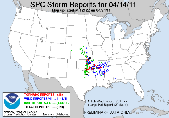
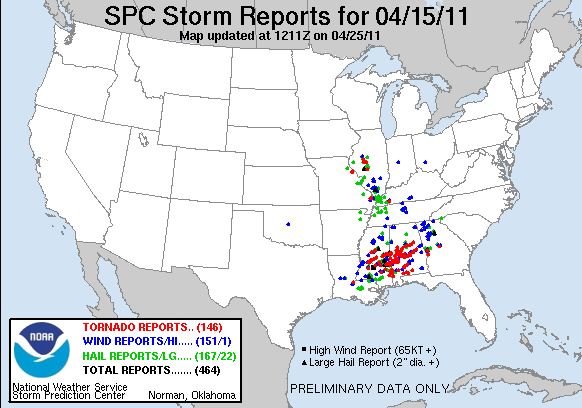
As April draws to a close, there have been some 752 reports of tornados. That number will come down dramatically, however the record confirmed touchdowns is 267 for April. It won't come down that much. So this will go down as the worst April for tornados in recorded history.


So far this year we're up to over 1200 reports of tornados...the record being over 1800 in 2004. We still have a long way to go here...and again that 1200 number is loaded with reports from the same tornado...so that number will come down in the end. Yesterday was the first day without a tornado report in the US in about a week and a half. Very impressive for April!

Here are all the tornado reports so far this April...


Thanks for reading and have a great weekend!

Joe

Friday, April 29, 2011

Not a lot to talk about as far as our forecast goes...there will be cooler air coming back in over the weekend, as highs should get to around 70 tomorrow followed by the 50s to near 60 on Sunday with more clouds filtering out the sunshine as a cold front comes through. Aloft the winds will remain from the SW so some moisture will stream in above the surface from the SW part of the country at times over the weekend. We should again moderate early next week after a chilly start Monday morning.

Once again let's spend some more time on the tornadoes in the SE part of the country. Earlier today the 1st EF5 (201+ mph) tornado was designated. This occurred in NE MS (Smithville) Reed Timmer, who was down there, had this interesting tidbit...there was a 1965 Chevy Pick-Up truck that was in front of a house that eventually was demolished by one of the tornadoes. They've yet to find that truck...it's disappeared. Odds are it's been flung 100's of yards somewhere...rolled on the ground for hundreds of feet and was shredded during this process.

We've shown you over the last several days, all the damage from the ground, also damage from the air...how about from space. While you can see the specifics, you can see how the tornadoes left scars in the earth's foliage as the made progress through the SE part of the country. Take a look at this, but you need to look carefully! Click on the graphic to make it larger.


Pretty amazing stuff. This next photo is from Meteorologist Mike Smith in Wichita. Again you can make out the scars in the land from the tornado tracks...


It's not the yellow lines that you looking for...it's what's immediately above those lines that's very impressive.

As you know, while Doppler radar can't pick out tornadoes, it can pick out where the winds are rotating in the atmosphere. While not perfect, in the case of the SE the other day, the storms were all rotating and many of those rotations were in fact tornadoes. There is a way of plotting all those signatures on a map and show you the scope of the rotational couplets that Doppler was showing through the course of the outbreak. Take a look at this map from Severestudios....


Pretty impressive once again!


The NY Times has some great material concerning the outbreak...from maps to images to video. Take a look at this, some of the destruction.

Finally, I showed some of these during the noon show today...essentially headlines from today of some of the newspapers in that part of the country...interesting to see their perspective...take a look.

From the Birmingham News
From The Anniston Star in MS


and lastly the Tuscaloosa News


Have a great weekend and I'll try and update the blog sometime tomorrow PM.


Joe

Thursday, April 28, 2011

Not even sure where to begin after watching the carnage from the storms last night in the SE part of the county. As of this writing the death toll is now up to 272 (180 in AL) and that number sadly will continue going up as they slowly and methodically work through the wreckage from the 164 reports of tornados last night.

Lets actually start there. The difference between Tornado reports and Tornadoes. The Tuscaloosa tornado was widely witnessed and no doubt generated dozens of reports while the storm was on the ground for what seemed like miles on end...and potentially the same storm created various tornadoes for many many miles. If you saw the tornado and reported it and I saw the SAME tornado and reported it...it would count as 2 tornado reports of the SAME tornado. This is why, so often there are SO many tornado reports on the map, yet when the research is conducted and the NWS determines the paths and number of actual different tornadoes, this number comes way down. It's fair to say, with the increased number of chasers out there over the last 15 years or so, that IF this would've happened 20 years ago, odds are there wouldn't have been as many reports of tornadoes. Although perhaps with the storms moving through populated areas the reports would've been closer. Regardless, my suspicion is that the 164 reports will in reality come WAY down in terms of the number of ACTUAL tornadoes. It is still impressive.

How does this compare in historical terms. Well the benchmark for tornado deaths is the infamous Tri-State Tornado back in March of 1925. It killed at least 695 people. In 1840 in Natchez, MS a tornado is believed to have killed around 315 people. Then the other, more recent outbreak is the infamous Super Outbreak in 1974. This outbreak killed 315 people with 148 actual tornadoes. So the numbers have been higher int he past sadly. This is the 3rd largest death toll since 1950 however which is significant for so many reasons.

There is some talk out there and it's an interesting discussion, not only by non government meteorologists but also from NOAA folks as well, about why the death toll was so high considering all the advances and the fabulous warnings/watches that were in effect for hours/minutes before the storms struck. For the most part, the word "surprise" shouldn't really be part of the conversation. this was so well forecasted, the information relayed so impressive by the media down there. The vast  population, except in some very unusual situations, was as informed about this outbreak/situation than at any other time. However there are circumstances that may have created issues for the various waves of storms that moved through. Mike Smith who used to work in the TV world back in the day and now is part of Accuweather wrote a though provoking blog on this very subject. Take a look.

The folks from NOAA will be assessing this over the next several months, initially giving ratings to the destruction and eventually, learning more about HOW people responded to the disaster before, during and afterwards. What actions did they take, when did they take them. A tremendous amount of information will be gleaned from all this and hopefully we'll learn more.

From the outside looking in however the response from the media during the event itself was amazing. I watched a lot of coverage from a meteorologist by the name of James Spann. Flawless work in my opinion. I'm sure others did as well...but this man was as solid as they came yesterday. Nothing fancy, no crazy, complicated radar analysis, just plain and simple. No 3D fancy graphics again simple is better. Something that many in the world of TV could learn from I think. Of course when you have a tower camera from Tuscaloosa showing the tornado, there really isn't much of a need for fancy stuff...the images do the talking for you.

The Weather Channel also provided good coverage and are now serving as a clearing house to some of the amazing videos that are circulating. I've seen some of these already, we've shown many on the news today with more to come...take a look.

The NWS's local offices in several states are busy now analyzing the tracks/paths and trying to figure out the intensities using the EF Scale. So far I believe there has been 1 EF4 tornado so far this year, that being near St Louis last week ( my memory may not be good on that fact though). No doubt, by looking at the damage there was certainly EF3-4 damage there. EF5 damage may be somewhat harder to come by. Greesburg, KS and Parkersburg, IA both were classified as EF5's...with winds 201+  mph. Here is a simplistic defination of EF5 damage...

Strong framed, well built houses leveled off foundations and swept away; steel-reinforced concrete structures are critically damaged; tall buildings collapse or have severe structural deformations.

Now by looking at the video it does seem like this criteria was met in some instances, however they also look very hard at the construction of the buildings destroyed and this plays a large role in tipping the scales from and EF4 to and EF5.

Other tentacles to the story...no power...for days and weeks to come for many. Now no gas sice the stations don't have power...the ones that do are tapped out. Alabama Power officials are saying they have restored power to 93,000 homes since the peak of the Wednesday storms. At the time of this writing 319,000 customers were still without power in Alabama. 148,000 customers in the Birmingham metro area are without power. 135,000 in the western area are still without power. No water for many. Here is a storm blog from WBRC-TV with updated information...including a higher death toll in AL (192).

Finally FOX4 also has information/videos on the web page...take a look at some of there work.

So much more to write about...I'll do another blog tomorrow.

Joe

Sunday, April 17, 2011

As rarely as I have to do this, I'm concerned that I'm going to have to make significant downward revisions to the forecast for Tomorrow and Tuesday.

My forecast philosophy is pretty simple. Make the forecast and keep the forecast. It's rare that I make more than minor updates to a forecast I make on Saturday for the next 5-7 days. By minor I mean maybe a 2-3 degree change one direction or another, even that is somewhat unusual, especially for the first 3-4 days of my original forecast. Every so often though, that gets blown out of the water and today may be one of those days. It's all because of a warm front that now lies just north of here and may go a bit farther north today, placing us in the warm air for a little while. The problem is that tonight that front should sag farther south, effectively changing the same front from a warm front to a cold front. Then this newly crowned cold front will waffle down towards the Lakes region and go stationary and hence become a stationary front on Monday night into Tuesday. We're lucky the atmosphere is loading up with moisture yet, or that the winds aloft aren't going to be perpendicular to that front for a prolonged period of time, although they are setting up to do that for awhile at least. It's a heavy rain set-up, and while I'm expecting rain. the heaviest may be farther north of the metro. Slightly different set-up here and it's a pattern that screams heavy rainfall/flooding.

I'm getting ahead of myself. Take a look at the forecast off the NAM model for tomorrow @ lunch...


Now look at Tuesday @ lunchtime...


The location of this front is key to the temperature potential, or not, for the next several days, and as a result, it's possible there could be a 30-40 degree swing in highs from the far north to the far south side of our viewing area, especially TUE...how KC fares in the wavering front will determine how warm or chilly we are...north side of the front means low clouds/lighter showers. South side of the front means warmth and humidity. I was hoping we'd be either closer to the front or on the south side of it. The modeling since yesterday has been foretelling a different story. Today its saying the same thing and I'm going to probably bite on this for the evening newscast. Hence the MAJOR downward trends int he temperatures for the next several days.

This front, aside from the temperature headaches, also warrants attention because of the potential of storms. We'll be pretty capped for most of the day on TUE...there may be some activity out there MON night and again later Tuesday. There isn't a strong disturbance though to set everything off. The SPC generally has areas from KC eastwards under a slight risk of severe weather. Perhaps the higher tornadic risk on TUE would be towards the SE part of the state up towards the Hannibal,, MO region and eastwards. regardless another busy week of severe weather is expected with the highest days being TUE and then again potentially on FRI. The heaviest rain set-ups may affect areas farther south of KC towards the I-44 corridors from all this story weather in the Plains & Ozarks for the next 5-6 days.

Sadly the death toll from yesterday's outbreak continues to inch up. Almost 2 dozen at last count and still several a re missing. I posted this AM the tower cam shot of a tornado moving in the rain through downtown Raleigh, NC on our MORNING SHOW FACEBOOK PAGE...here is another tornadic storm. Keep in mind that most homes I understand in this part of the country do not have basements and many communities don't have siren systems.

Joe

Saturday, April 16, 2011

The sun is out, but it's still awfully chilly out there. Good afternoon and welcome to the FOX 4 Weather Blog on a day this chilly day.We should be talking about College Football or something, instead of a baseball game or at least it feels that way!. Temperatures are in the 40s now but will soon pop into the 50s as the sun heats this chilly airmass on top of us. Our 5000' temperatures were down to -4C this AM, so in a way the clouds that we had combined with all that wind keeping the atmosphere mixed up overnight, prevented a hard freeze in the area earlier this AM.

The powerhouse of a storm, that created dozens of tornados over the last couple of days is moving away from the region now, and the moisture, wrapping in behind the storm is doing the same thing. Here is an up close look at E KS and MO showing the back edge of the clouds...


So now that the sun is out, it'll start to feel a bit better, but the air is still chilly aloft and it will take awhile too heat up. Odds are we'll be in the 55-60 range before the day is done...then drop down to the 30s to near 40 tomorrow AM...as the winds switch back towards the S/SW.

Tomorrow looks much nicer from a temperature standpoint as highs reach the 70 degree mark with much less wind out there through Monday AM before the winds pick up a bit more MON PM.

Our next disturbance is due in Tuesday, ahead of this there may be some isolated showers/storms MON night or early Tuesday Morning, then the storm should move into the area in the PM...we'll need to watch this, because if the instability can build up, then the risk of severe storms will be increasing during the PM on TUE.
There does appear to be a large spread in temperatures possible from the far NW side of MO to the Lakes area on TUE...here is the 1PM map off the NAM for Tuesday, showing the large temperature spread. We'll see if this pans out...I doubt this is totally realistic...


There were some scary times yesterday in the SE part of the country. All told, nationwide there were almost 100 reports of tornados, granted the realistic number of tornados will be much lower as many of the tornado reports of witnesses seeing the same tornado. So the actual number of tornados will be whittled down, however it was pretty rough. Between THU and FRI almost 125 reports were loggeed on the SPC website...take a look at the map. First Thursday...


Now yesterday...


Here is a closer view of all the reports...these are just for tornados.


One of the scarier stories occurred down towards the Talladega Speedway. Thousands of race fans were camped out for a weekend of racing, when severe weather threatened. The Speedway was under a tornado warning for awhile, sending the campers scrambling. I would imagine the Emergency Manager there was stressing like crazy. It's a nightmare scenario for the EMs out there. There is only so much preparation that a community can do to prepare for something like this, and now when you're throwing 1000s of campers with very mobile facilities into the mix...certainly a scary combination. Thankfully all went OK as the tornadic potential slid to the south of the Speedway.

The NWS in Jackson, MS has put together this map.


Here are some pictures from the newspaper in Jackson.

That's about it for today. Have a great weekend

Joe

Sunday, April 10, 2011

The Dry Line, which rarely passes through KC each year (maybe a couple of times tops) is in the process of working into the metro area now as I type this. The dewpoints, behind the dryline, go down. So far we've seen dewpoint drops of 10+ degrees in Topeka as the drier air has replaced the 60 or so dewpoint values with 50 dewpoint values. It's even drier out to the west of here where the dewpoint in Mnahattan has dropped to 41 as of the Noon hour. This passing dryline will eliminate the threat of rainfall/storms for the local area. However as that transition moves farther to the E/SE it will stall and may provide the necessary boundary for sparking storms later this afternoon....however that area. to the E/SE of KC remains rather capped as of this writing, so it may take awhile for something to go up. Here is the latest from the SPC concerning the potential of severe storms...again notice that it's farther away from KC...


Basically the area from Butler to Nevada To Marshall to Kirksville to the Lakes area still needs to be monitored.

The winds have also been blowing pretty good with gusts so far to over 35 MPH. These winds may pick up a bit more during the afternoon.

A cold front will be the next airmass change around here, that's due to move into the area this evening. Temperatures this AM in the western plains were well down into the 30s, so the air is seasonably cool and that is what I'm expecting tomorrow, a seasonably cool/nice afternoon. Here is the latest surface map showing several airmasses, note the dewpoints in green and the temperatures in RED...also notice the wind barbs...


Click on that image to make it larger...

Last night was a rough night for the folks up towards IA...there were 27 reports of tornados in the Hawkeye state and while several are reports of the same tornado, there certainly were some nasty cells up there. Here are the storm reports, Mapleton, IA was the community that was hardest hit.


Click on that too make it larger...the RED dots represent the reports of a tornado. The storms were impressive. Reports indicate that more than 60% of the town of Mapleton was damaged or destroyed...here is some video of the tornado and the aftermath.


Also one of our numerous chasers that help out FOX 4 was on the storm as well. Here is Ben Prussia's video from the tornado...thanks Ben. I saw you on Spotternetwork up there...was wondering if you were able to capture that storm!


As you know sometimes chasers are a bit over the top with these things, however I did notice last night that more than a few chasers, after watching the tornado and seeing what it did to a small community, immediately went from chaser mode to rescue mode as a bunch stopped and helped folks out of the rubble. Good job!

It looks like the Tornado risk today, at least the bulk of it, will be shifting up towards Wisconsin and NW Illinois.

Joe

Saturday, April 9, 2011

Well the warm air has certainly arrived as temperatures are soaring through the 80s as I type. KCI is @ 84 now and may top off close to 90 before the afternoon is done. The record today is 89 set back in 1930. Doable if this keeps up.

The moisture (dewpoints) have also surged, we're in the 65-67 range now which is the highest so far this young spring.


The GREEN is the dewpoints and the RED lines are the temperatures. Pretty juicy out there. Instability is building but since the air aloft is so warm as well, we're capped and won't worry about storms today.

Our developing storm will be taking shape across the plains states tomorrow. It's becoming more and more apparent that the potential of severe storms will be east of KC. There is a small window, between Noon and 3PM that something briefly could develop on top of us, buts the odds favor a bigger, more substantial outbreak farther east towards Columbia/St Louis/Kirksville. The Lakes area/Sedalia/Clinton/Chillicothe are still in the game though. This AM I painted an enhanced chance of severe weather in this boundary and I'll keep that going for tonight's newscast. This area also would have the potential for an isolated tornado. Again as mentioned several days ago, the fast moving storms will be flying @ close to 60+ MPH...so whatever happens will be quick!


The SPC has this area in a SLIGHT (I hate that word) risk.


Notice they've removed the KC area from even the SLIGHT risk of severe weather and I really don't disagree at this point. Should the dry line set up farther west then this will radically change things tomorrow afternoon for the worse.

Cooler weather is likely on Monday then a nice warm-up for TUE/WED followed by another rain chance on THU/FRI, although after tomorrow, the severe weather risk may be gone for the week.


That's about it for today...at this point it looks like we're dodging a bullet for tomorrow. Need to still watch it though.

Joe

Sunday, April 3, 2011

Strong winds are blowing as expected in the region...with winds gusting to almost 50 MPH around parts of the area. Not only are the winds strong @ the surface, they're also blowing pretty good aloft as well from the SW. Topeka has already set a record high of 87...ours is 82 set in 2005 and we're 81 now. That will break no problem in the next couple of hours.

Aloft the atmosphere is warm as well. Check out the 7AM map @ 10,000 feet, or an altitude that we roughly look for the placement of the CAP....although in reality it's even lower today but you get the idea.


The winds at that level were out of the SW at close to 50 MPH...temperatures at that level are in the 50s, which is way to warm to allow convection to spark through, hence the lack of cloud cover developing in the vertical so far this afternoon. The RUC is persistent in cooling these mid-level temperatures this afternoon, perhaps overly so. The folks in Topeka will be sending up a special balloon at 3PM today to get another look at the atmosphere. My feeling is that through 6PM, and perhaps 7PM we're fine here.

The CAP should break as the atmosphere cools off at that level after 6PM tonight, combined with the progress of a cold front which is now slicing through NE...


This cold front should arrive, very close to sunset...and it'll be a race to see if the CAP breaks in time, or if the front races through and the storms that form are behind the front. That potential would increase the hail threat and virtually eliminate the tornado threat from the storms. Although I've never been very keen on the potential of tornados with this set-up.

The atmosphere is certainly unstable. Here are the latest CAPE values, the higher the number the higher the instability...

The colored hatched area represents the amount inhibition that is holding the atmosphere in place...or essentially the strength of the cap. It's a lot now!

So the bottom line is that storms should pop between 7-9pm tonight. They will rapidly become severe with the highest potential being hail/severe winds...

I'm out of time...need to get to work.

Joe

Saturday, April 2, 2011

What a great day. Winds are rather light (that will change) and temperatures are getting to that "perfect" level with readings as of this writing in the 65-70 range with another 5 degrees expected before the afternoon is done. The air is nice and dry, with dewpoints in the 30s now (that to will change).

First the dewpoint situation. We're about to get dewpoints in the 50s+ to near 60 or so tomorrow. That moisture is now down towards the gulf coast area. It's starting to move to the north, and while the progress is slow now, notice that by tomorrow the progress will be a lot faster...

Here is the 1PM surface map, I've shaded in the dewpoints of 60 or above and outlined the 70+ dewpoints confined to the coastline for now.

Here is the 12hr RUC forecast for dewpoints...notice the dewpoints are on the move northwards...


The 60 degree dewpoints are the 1st lighter shade of orange. Now here are the surface winds which will be increasing all night long...eventually gusting to 25+ by daybreak (or earlier) tomorrow.

So the dewpoints (surface moisture) will increase rapidly later tonight into tomorrow AM...The surface winds are following suit, and eventually tomorrow, may gust to near 40 MPH. Those winds will be from the south. The temps in TX now are in the 80s and that air is heading this way. Don't be surprised if maybe for a few hours we have some low clouds around...the strong winds will mix the atmosphere enough to mix out that cloud cover.

Then we wait. As the air heats up tomorrow at the surface, aloft the air will be warming up as well. As a result we'll be "capped" through much of the day. Yesterday's thoughts concerning storms and the potential for severe weather has not changed. The front is due in between 7-10PM through the I-70 corridor. This should be enough to break the cap and a rapid increase in storms is expected from north to south before sunset tomorrow night. These storms obviously can be severe...with wind/hail being the main threats to whatever happens, especially through 10PM or so. Here is what the SPC thinks...

These are probabilities for severe weather. The SPC looks at these things a bit differently in a sense than what you might think of...here is their explanation...

The probabilities used in the SPC Convective Outlooks are known as subjective probabilities. The forecasters make their best estimate of the probability of an event occurring. The probability values forecast are not created automatically by a computer or via statistics, but by the SPC outlook forecaster. 

The probabilities that you see on the graphics represent the probability of one or more events occurring within 25 miles of any point during the outlook period. This definition is used as the probability of severe weather at an given point is quite small. Also the Convective Outlook is not a small-scale, short-term forecast, but one that covers the entire U.S. for periods up to 24 hours. There is a large amount of uncertainty in forecasting severe weather on these scales. How many times have you experienced a tornado in your neighborhood? For most people, the answer is never. Now think of how many times severe weather has occurred within 25 miles of your location. It's probably safe to say that you can think of some close by severe weather events. How large of an area is a circle with a 25 mile radius?
The front moving through will drop our temperatures some 30-40 degrees on Monday as a blustery start to the work week is expected with highs 45-50 or so in the PM...with NW winds of 20-30 MPH.

The rest of the week looks pretty good with a rapid warm-up on Tuesday, followed by a couple of weak disturbances on THU and SAT with some rain chances there.

Check out the swing of temperatures @ the 5000 foot level, showing these airmasses moving in and out.


Pretty impressive swings coming up...

Joe

Friday, April 1, 2011

It's been a long time since the satellite picture @ 1PM looked something like this...


That, my friends, is generally clear weather across the region. Temperatures as of 2PM are up to 62 @ KCI with the potential of another 3 degree rise in spots. Our convective temp is 60 from the AM's sounding @ Topeka so we're in the process of bubbling up some nice fair weather cumulus clouds as we speak. Perhaps leveling out the temps a bit for the next few hours. Wonderful out there!

Weekend thoughts have not really changed. Shooting for highs in the 60s tomorrow and 80s on Sunday. There may be some 85+ temps in the region, especially S/SW of KC Sunday afternoon if things work out.

Won't last though as a seasonably strong cold front will usher in MUCH chillier weather by MON AM. this will result in a 30+ degree drop in the temperatures from Sunday PM to Monday PM with reading in the 40s and gusty NW winds of 15-30 MPH expected to start the next work week. Add in some drizzle (hopefully that's it) and that is not a nice day showing up. So my weekend weather story will be the FLIP int eh temperatures from Sunday to Monday.

Another topic to my weekend forecasts will be the potential of thunderstorms later Sunday PM into Sunday night as a strong cold front moves into the region. The atmosphere aloft will be rather warm so we'll be capped for much of the day, but as this cap erodes later Sunday, and as the front edges into the 36 highway corridor, storms should erupt and rapidly move off towards the east or ENE. The storm's movement should be close to 45-55 MPH, this should throw up a red flag for the potential of some severe weather with wind/hail being the primary threats as the storms get their act together later Sunday. Don't be surprised if we are under some sort of WATCH by later SUNDAY afternoon.

Again it appears the main threat would be 50-65 MPH winds with the individual storms themselves. The hail threat is there, but shouldn't get too out of control.

Here are SPC's thoughts concerning Sunday...


Here is the NAM forecast for SUN @ 7PM...notice the fronts location, just towards the north of the I-70 corridor...storms should initiate up there and move eastwards, storms out west should move our way. Also the storms to the north may create an outflow and/or push the front towards us, also creating more storms nearby so again from 6PM SUN through 3AM MON, there will be a window for some nasty weather.


The cold air sweeping into the area MON AM will be brief, and by TUE AM will start to move away and as the winds pick back up out of the south on Tuesday, temperatures should return to near average, followed by somewhat warmer air again by WED of next week and then another setback towards the end of next week.

By the way, the New England area is getting themselves a early Spring snowstorm...with amounts in MA in the neighborhood of 1-6", while ME is in the 6-12" range so far with moderate snow falling across that area as I type this.

Have a great weekend...I'll have more tomorrow afternoon.

Joe