The powerhouse of a storm, that created dozens of tornados over the last couple of days is moving away from the region now, and the moisture, wrapping in behind the storm is doing the same thing. Here is an up close look at E KS and MO showing the back edge of the clouds...

So now that the sun is out, it'll start to feel a bit better, but the air is still chilly aloft and it will take awhile too heat up. Odds are we'll be in the 55-60 range before the day is done...then drop down to the 30s to near 40 tomorrow AM...as the winds switch back towards the S/SW.
Tomorrow looks much nicer from a temperature standpoint as highs reach the 70 degree mark with much less wind out there through Monday AM before the winds pick up a bit more MON PM.
Our next disturbance is due in Tuesday, ahead of this there may be some isolated showers/storms MON night or early Tuesday Morning, then the storm should move into the area in the PM...we'll need to watch this, because if the instability can build up, then the risk of severe storms will be increasing during the PM on TUE.
There does appear to be a large spread in temperatures possible from the far NW side of MO to the Lakes area on TUE...here is the 1PM map off the NAM for Tuesday, showing the large temperature spread. We'll see if this pans out...I doubt this is totally realistic...

There were some scary times yesterday in the SE part of the country. All told, nationwide there were almost 100 reports of tornados, granted the realistic number of tornados will be much lower as many of the tornado reports of witnesses seeing the same tornado. So the actual number of tornados will be whittled down, however it was pretty rough. Between THU and FRI almost 125 reports were loggeed on the SPC website...take a look at the map. First Thursday...
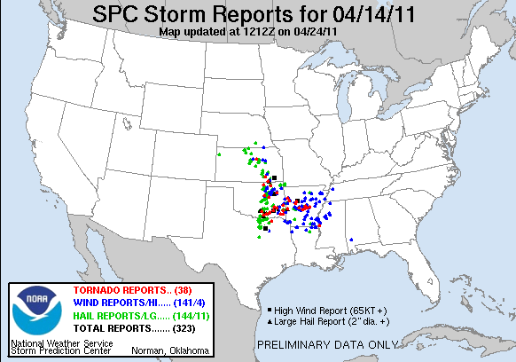
Now yesterday...
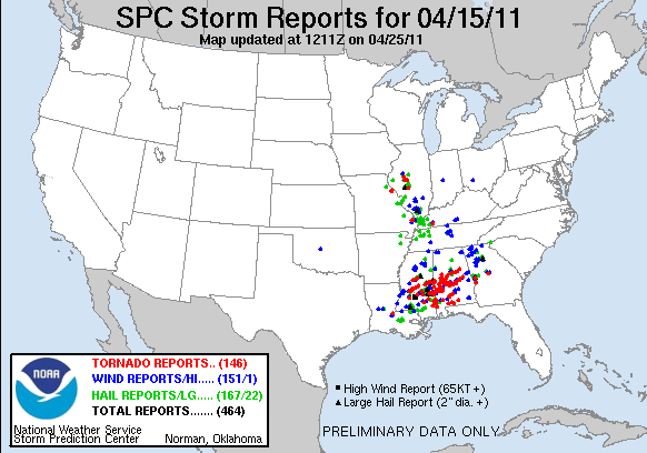
Here is a closer view of all the reports...these are just for tornados.

One of the scarier stories occurred down towards the Talladega Speedway. Thousands of race fans were camped out for a weekend of racing, when severe weather threatened. The Speedway was under a tornado warning for awhile, sending the campers scrambling. I would imagine the Emergency Manager there was stressing like crazy. It's a nightmare scenario for the EMs out there. There is only so much preparation that a community can do to prepare for something like this, and now when you're throwing 1000s of campers with very mobile facilities into the mix...certainly a scary combination. Thankfully all went OK as the tornadic potential slid to the south of the Speedway.
The NWS in Jackson, MS has put together this map.

Here are some pictures from the newspaper in Jackson.
That's about it for today. Have a great weekend
Joe
No comments:
Post a Comment